
Australian Notices to Mariners (NtM) are the authority for correcting paper nautical charts and publications published by the Australian Hydrographic Office (AHO).
Australian NtM are published by the AHO in 25 fortnightly editions each calendar year and are numbered from 1 onwards. They are issued to correct and maintain the following AHO published products:
- AUS paper charts (coverage includes Australian, Timor-Leste and Australian Antarctic Territory waters)
- SLB paper charts (coverage includes Solomon Islands)
- PNG paper charts (coverage includes Papua New Guinea)
- Australian National Tide Tables (AHP11)
- Mariner's Handbook for Australian Waters (AHP20)
- Chart and Publication Maintenance Handbook (AHP24)
It also notifies mariners of the release and withdrawal of AHO published navigational products.
Notices to Mariners for Electronic Hydrographic Products
AusENC has its own update service. For details see the AusENC section of this web site.
AusTides is occasionally updated by software updates. To download the latest updates see the AusTides section of this web site.
Types of Notices to Mariners
Australian NtM are divided into the following sub-types:
- NtM Updates
- A NtM is issued for the prompt dissemination of textual permanent navigational information considered important to safe navigation and which is not of a complex nature. These NtM are also called 'Permanent Notices to Mariners'.
- Blocks and Notes
- A Block is produced to assist the mariner to update their chart where there is significant new data important to safe navigation in a relatively small area, or where the volume of changes would clutter the chart unacceptably if amended by hand. Blocks are small sections of printed chart that are designed to be cut out and manually pasted onto the relevant chart.
- Notes are also produced to assist the mariner to update their charts. Notes are printed versions of new or amended chart notes designed to be cut out and manually pasted on the relevant charts.
- Preliminary NtM (P)
- A Preliminary NtM (P) is issued where early promulgation to mariners is needed and:
- Work will soon be taking place (such as a change to a navigation aid). A permanent NtM will be promulgated when the change is completed.
- Information has been received, but is too complex or intensive to be promulgated by a permanent NtM. A precise summary of the overall changes together with information important to safe navigation is given in the (P) notice. Full details will be included in a new chart or new edition.
- A Preliminary NtM (P) is issued where early promulgation to mariners is needed and:
- Temporary NtM (T)
- A Temporary NtM (T) is issued where the information will remain valid only for a limited period. A (T) notice will not be initiated where the information will be valid for less than one month. In such circumstances this information may be promulgated as a Radio Navigation Warning or as a local notice to mariners.
Notices to Mariners Tracings
NtM Tracings are produced to assist the mariner to update their charts. They are diagrams that provide guidance on how to apply NtM updates that require accuracy in positioning them. They are overlaid on the chart and the position of each feature can be pricked through to the chart with a pin to enable the feature to be drawn in position. A set of tracings is available for each of the 25 published Australian NtM Editions.
Cumulative Lists
A Cumulative List is produced to assist mariners to update their charts. It is published twice a year (in April and October) and lists the current edition date and all the NtM updates that have affected each Australian Navigational Chart in the last two years. If a chart has not been affected by a notice during that period then the most recent notice, if any is shown.
Note that mariners can look up the current edition date of a chart at any time of the year by using the AHO Chart Explorer.
Notices to Mariners as they relate to New Editions and New Charts
A New Edition of a chart is produced when there is a large amount of new information or a significant amount of accumulated information for a chart that is non-safety critical. New Editions incorporate all NtM issued for the previous edition. New editions are promulgated by NtM and supersede previous editions of the chart that should be replaced. NtM issued after a New Edition is released should not be applied to the previous edition as they are applicable only to the New Edition’s datum and imbedded information.
A New Chart is issued if it covers an area not previously charted to the scale shown, or it covers a different area to the existing chart, or it introduces new depth units (for example a conversion from imperial to metric units). New Charts will also be produced when converting an existing chart to a modern datum (to the WGS84 horizontal datum and LAT vertical datum).
Charts superseded by New Editions and New Charts are promulgated by NtM. Superseded charts are not maintained by NtM and should not be used for navigation.
How do I obtain Australian Notices to Mariners
Australian NtM editions are available from the following sources:
- The Australian Notices to Mariners section of this web site.
- From Distribution Agents who provide a paper Notices to Mariners service.
Alternatively, if you know the chart number you are after, you can use our Australian Chart Index (ACI) to find your chart, then access a cumulative list of Notices for that chart via the view option. This option is recommended if you wish to correct a small number of charts and need to know which notices are applicable to these specific charts.
If you want to automatically receive NtM via email for the charts you hold in your portfolio you can register for our eNotices service. Then as Australian NtM are published you will be automatically emailed only the NtM that affect your portfolio of charts.
Why do I need to update my charts and publications for Notices to Mariners?
Notices to Mariners (NtM) are the means by which all national hydrographic offices provide the latest safety-critical information to mariners. It is therefore imperative for all mariners to update their charts and nautical publications for NtM to ensure that they continue to be safe to use.
Types of safety-critical information that may be issued as an NtM or NtM block to update a paper chart or nautical publication include but are not restricted to:
- Reports of new dangers significant to surface navigation eg shoals, obstructions and wrecks,
- Changes in general charted depths,
- Changes in vertical clearances of bridges,
- Changes in cables and pipelines both overhead and on the sea floor,
- Significant changes to navigational marks and lights
- Changes in prohibited/restricted areas, anchorages etc
- Additions and deletions of conspicuous landmarks
- Changes to port infrastructure eg changes to wharves, reclaimed areas, available depths, works in progress and new port developments
- Changes in pilotage areas etc.
Printing Tracings and Blocks
It is important that tracings and blocks are printed at the correct size so that they will ‘fit’ the corresponding chart. To ensure correct fit, mariners should note the following:
- Some printer settings may distort the size of the tracing or block being printed. Tracings and blocks should be printed at 100% size. Any printer setting that implies the size or scale of the image will be changed (such as ‘fit to’, ‘reduce to’, ‘shrink’ or ‘expand’) should not be selected.
- Editions of Australian NtM are ‘pdf’ files that are best viewed with the latest version of Adobe Acrobat Reader.
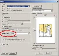
- When printing blocks and tracings using Adobe Acrobat Reader, ensure that the ‘Page Scaling’ setting is changed to ‘None’.
- Blocks published from NtM Edition 16/2008 (15 August 2008 onwards) have block dimensions written on them. Mariners can therefore check the printed size of these blocks with a ruler.
- The appropriate check of print accuracy is how well the printed block or tracing fits the corresponding chart. For tracings this is a matter of how well the static information and graticule lines drawn on the tracing matches the corresponding underlying chart. For blocks it is a matter of how well the information at the edges of the block match up with the corresponding underlying chart.
- Variations in size of up to 1mm can be expected. Mariners should also note that tracings should only be used as a guide when applying NtM updates.
- Mariners experiencing difficulties with printing blocks and tracings to correct size should contact the AHO Notices to Mariners section.
How do I apply Notices to Mariners to my charts?
Please refer to the Chart and Publication Maintenance Handbook (AHP24) for detailed information regarding application of NtM to your charts.
Are my charts and publications up to date for Notices to Mariners when I purchase them?
AHO Paper Charts:
If you have purchased your AUS, SLB & PNG paper navigational charts from an authorised AHO ‘Correcting Agent’, your charts should be up-to-date for NtM at the time you purchased them. However you will need to update them yourself from this point forward until a new edition is released.
If you have purchased your AUS, SLB & PNG paper navigational charts from another source such as an AHO authorised ‘Non Correcting Agent’ or a retail outlet of one of our authorised agents, it is unlikely that your charts will be up-to-date. You should therefore update them yourself before you use them and then keep them up-to-date until a new edition is released.
Authorised agents are listed as ‘Correcting Agent’ or ‘Non-correcting Agent’ on our Distribution Agents list.
Nautical Publications:
Unless you have purchased a brand new edition or reprint of a nautical publication it is unlikely that it will be up-to-date for NtM. You will therefore need to check that your copy contains the latest NtM and it will be up to you to transpose corrected information onto the pages of your book.
How do I determine how up-to-date my paper chart is?
To determine the update status of your copy of a chart you should conduct the following checks in the following order:
Identify the chart number of our chart. The chart number can be found on the top left or bottom right corner of your chart. In the example below the chart number is ‘Aus 821’
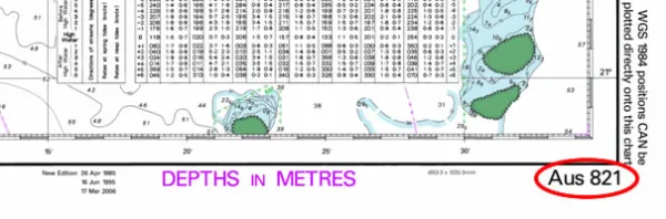
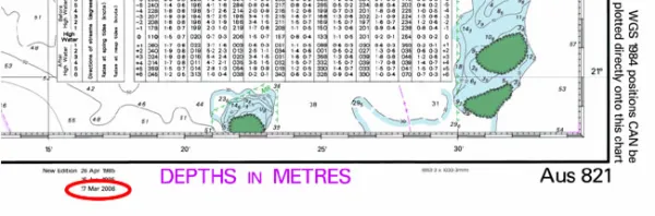
Identify the edition of your chart. The edition date can be located at the bottom of a chart. If a number of edition dates are listed, the edition of your copy is chronologically the most recent date listed. In the example below, the edition date is ‘17 March 2006’.
Check the last NtM to be applied to your chart. The NtM that have been applied to your chart are listed on the chart’s bottom left corner. NtM are numbered from ‘1’ onwards each calendar year and are therefore unique and specific to a particular piece of safety critical information. The numbers written in the larger text represent the calendar year a NtM was issued. The numbers written in the smaller text are the Notice numbers. In the example below, 4 NtM have been applied to this copy of Aus 821 and the last NtM applied is NtM ‘559’ of the year ‘2007’.
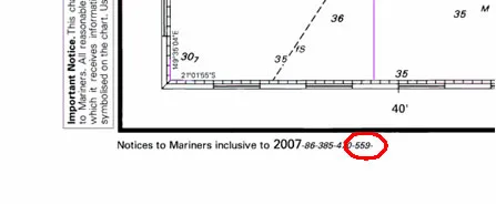
Note that if the NtM numbers are written in black type (like in the example) then the NtM have most likely been incorporated into the chart base prior to printing your copy. If the NtM numbers are written in magenta ink or appear hand written, then the NtM have been applied to the chart by hand correction.
Sea Dumping in Australia
The Department of Defence maintains records of known sites used for dumping materials at sea under superseded and contemporary environmental constraints. These range from sites used following World War II for unexploded ordnance, industrial dumping, to modern spoil grounds used to keep ports open.
Key sites with potential navigational significance, particularly for anchoring, trawling or other seabed activities, are shown on the relevant ENC and paper nautical charts published by the Australian Hydrographic Office. Information regarding spoil grounds is updated regularly, and information regarding wrecks is updated as they occur. For more information on sites known to have been used for disposal of unexploded ordnance, please refer to:
- National Unexploded Ordnance Program | Defence Activities | Defence
- UXO | Unexploded Ordnance (defence.gov.au)
Masters of vessels encountering unexploded ordnance at sea should follow the advice contained in the Mariners Handbook for Australian Waters (AHP24). Organisations requiring additional information regarding charted sites, or having updated information available, are encouraged to contact the AHO.